Grossglockner Ultra-Trail - Weissee Glacier World Trail - Elevation Profile, Aid Stations and Cutoffs
- Enzingerboden, Austria
- 35 km
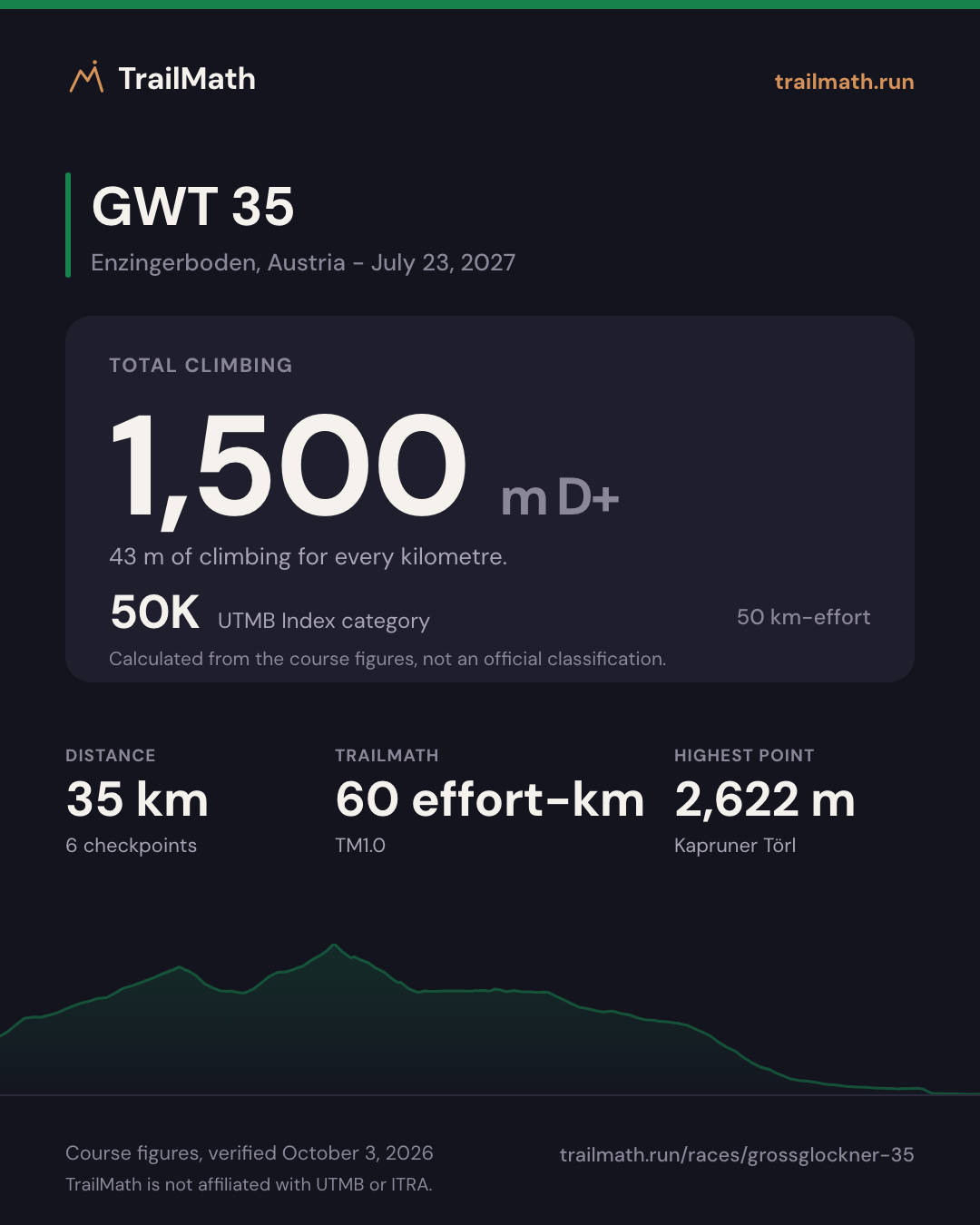
- 1,500 m D+
- 4 aid stations
Map, checkpoints and cutoffs Map · checkpoints · forecast opens Jul 14 Race-day forecast is live
Race-day conditions
Weather, daylight and your arrival time at all 6 checkpoints, set to the 08:00 start.
- Start
- 08:00
- Daylight at the start
- 05:37-20:54
- Aid stations
- 4
Course profile
Enzingerboden, Austria Kaprun, Austria · point-to-point
- Distance
- 35 km Finishes 500 m lower than it starts
- Elevation
- +1,500 m -2,000 m About 43 m of climb per km
- Highest point
- 2,622 m Kapruner Törl
Next edition Fri 23 Jul 2027 · 08:00
- Start
- Winner ~3h15 3h15 after the start
- Median finisher 2026 median 6h44 after the start
- Cutoff 10h after the start
Grossglockner Ultra-Trail - Weissee Glacier World Trail is a 35 km ultra-trail with around 1,500 m of elevation gain, starting in Enzingerboden, Austria. The overall cutoff is 10 hours. The highest point on the course is Kapruner Törl at 2,622 m.
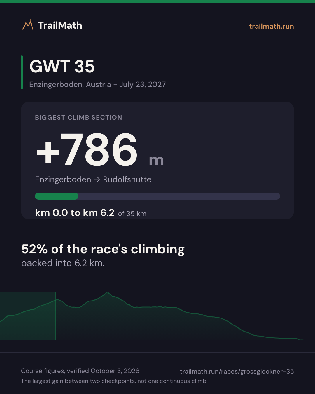
The biggest climb between checkpoints gains around 786 m from Start - Enzingerboden (km 0) to Rudolfshütte (km 6.19). The steepest sustained section on the elevation profile averages about 19% over roughly 3 km around km 10. The published checkpoint list has no crew-access points - check the official runner guide for assistance rules.
Data is approximate and courses change between editions - always verify against the official race guide.
Plan against the cutoffs
Enter a goal finish time and see estimated arrivals vs checkpoint cutoffs.
Estimate your finish
One Strava connection reads your last 90 days and estimates your finish on this course. Free, no plan needed.


Course math
Four numbers worked out from this course's distance, elevation and checkpoints.
TrailMath effort-km
60 effort-km
About 5 h for a mid-pack finisher (index 500). Not a pacing guarantee.
Distance + gain ÷ 100 + loss ÷ 200, beside ITRA's gain-only km-effort. Model TM1.0.
How TrailMath works →UTMB Index category
50K
50 km-effort (distance + gain ÷ 100). Calculated from the course figures, not an official classification.
Estimate your UTMB Index →Biggest climb section
+786 m
Enzingerboden → Rudolfshütte · km 0–6.2
The largest gain between two checkpoints, not one continuous climb.
Biggest descent section
−889 m
Mooserboden → Kesselfall Alpenhaus · km 19.6–27.8
The largest loss between two checkpoints. ITRA's km-effort ignores descent; TrailMath counts it: 60 km-effort.
Open in GPX Explorer →Share this race
Cards sized for Instagram and Strava.
Grossglockner Ultra-Trail - Weissee Glacier World Trail · 2026
Finish times, 2026 edition
521 runners started. 489 came back. Half of them took longer than 6:44:13.
Median finish
6:44:13
Half of the 489 finishers were still out there at this point.
The start line
93.9%
489 of 521 starters made it; 32 did not.
Men and women
Two medians on the same scale. The bars run from the start to the cutoff, so the gap between them is the gap in time.
Men
6:35:39
median finish; average 6:33:24
328 finishers, 67% of the field
Women
7:12:32
median finish; average 7:07:37
161 finishers, 33% of the field
0:36:53 separates the two medians, across 328 men and 161 women.
Where the finishers came from
35% of the finishers came from Germany alone.
| Nation | Finishers | Share |
|---|---|---|
| Germany DE | 172 35.2% | |
| Austria AT | 157 32.1% | |
| Czechia CZ | 47 9.6% | |
| Netherlands NL | 33 6.7% | |
| Poland PL | 21 4.3% | |
| Slovakia SK | 10 2.0% | |
| Italy IT | 8 1.6% | |
| Belgium BE | 5 1.0% | |
| Denmark DK | 5 1.0% | |
| United Kingdom GB | 4 0.8% | |
| Hungary HU | 4 0.8% | |
| France FR | 3 0.6% | |
| Ukraine UA | 3 0.6% | |
| Australia AU | 2 0.4% | |
| Bulgaria BG | 2 0.4% | |
| Spain ES | 2 0.4% | |
| Romania RO | 2 0.4% | |
| Sweden SE | 2 0.4% | |
| Belarus BY | 1 0.2% | |
| Greece GR | 1 0.2% | |
| Israel IL | 1 0.2% | |
| Lithuania LT | 1 0.2% | |
| Peru PE | 1 0.2% | |
| Russia RU | 1 0.2% | |
| Slovenia SI | 1 0.2% | |
| 15 other nations 5 other nations | 27 5.5% 5 1.0% |






















Showing 20 of 25 nations. Showing 25 of 25 nations.
Bar length is against the largest nation. The smallest counts are drawn at a minimum visible width, so their bars are not to scale.
How these numbers were computed
These are times for runners who finished. They exclude everyone who started and did not, so they describe how long finishing took, not how long the race takes. Bands with only a handful of finishers move a lot from one edition to the next.
We plot the median, not the average. A handful of very quick runners drags the average well below the time half the field actually beat, so the median is the honest number to plan against.
Nationality here shows who travels to this race, not who runs it best. That alone is why a host nation tops almost every list.
Computed from the full official results, verified October 3, 2026 - Official results
Ask the course
Ask GWT 35 anything about climbs, pacing, crew or cutoffs.
Answers come from this course's data, your plan and your training.
Which climb should I respect most?
Enzingerboden to Rudolfshütte: +786 m over 6.2 km, straight from the gun. Hike the steep sections at an effort you could hold for hours - the race is decided after this climb, not on it.
Is 6h a realistic finish for me?
6h would put you in the faster half of 2026 finishers - the median was 6:44:13. It means holding 10:17/km overall.
The Coach answers that once it can see your training.
Build your GWT 35 plan and your question is the first thing waiting in the Coach. Your first 5 questions are free, no card.
Build my GWT 35 plan14 days of Premium included.
To answer this for you, the Coach uses your training and your race plan.
Example answer
Your long runs peak at 10 km, so the plan builds to 4-hour long runs. Cutoff buffer at Mooserboden: 2h07.
14 days of Premium included.
Try asking GWT 35
Ask anything - we'll open your GWT 35 plan with your question ready.
Loading your Coach
See your training shape
Pick your weekly volume and training days to preview the plan structure - no account needed.
~42 weeks · peak ~8 h/week · 5 run + 2 strength days
Typical structure for your volume - your live plan adjusts sessions inside each week.
Make this your plan
Create your free account to generate the full week-by-week plan and adapt it with your coach.
Aid stations and checkpoints
| Checkpoint | Km | Cumulative gain (m) | Cumulative loss (m) | Cutoff |
|---|---|---|---|---|
| Start - Enzingerboden | 0 | 0 | 0 | - |
| Rudolfshütte | 6.19 | 786 | 0 | - |
| Kapruner Törl | 11.92 | 1,404 | 285 | Fri 12:30 |
| Mooserboden | 19.57 | 1,484 | 882 | Fri 14:00 |
| Kesselfall Alpenhaus | 27.78 | 1,494 | 1,771 | - |
| Kaprun (Finish) | 35 | 1,500 | 2,000 | Fri 18:00 |
Data is approximate and courses change between editions - always verify against the official race guide. Source: official race guide, verified October 3, 2026 - Official race website
FAQ
How much elevation gain does Grossglockner Ultra-Trail - Weissee Glacier World Trail have?
Grossglockner Ultra-Trail - Weissee Glacier World Trail has around 1,500 m of cumulative elevation gain and 2,000 m of loss over 35 km.
What is the cutoff time for Grossglockner Ultra-Trail - Weissee Glacier World Trail?
The overall Grossglockner Ultra-Trail - Weissee Glacier World Trail cutoff is 10 hours, with intermediate time barriers at major checkpoints. Winning times are typically around 3 hours.
How long is Grossglockner Ultra-Trail - Weissee Glacier World Trail?
Grossglockner Ultra-Trail - Weissee Glacier World Trail covers approximately 35 km, starting in Enzingerboden, Austria.
What is the highest point of Grossglockner Ultra-Trail - Weissee Glacier World Trail?
The highest point of Grossglockner Ultra-Trail - Weissee Glacier World Trail is Kapruner Törl at 2,622 m.
How many aid stations does Grossglockner Ultra-Trail - Weissee Glacier World Trail have and which allow crew?
The checkpoint table lists 4 major aid points between the start and the finish. Personal crew assistance is not part of the published checkpoint data - check the official runner guide.
Training for this race?
TrailMath builds periodized trail training plans around your goal race.
One Strava connection reads your last 90 days and estimates your finish on this course. Free, no plan needed.