Trail Verbier St-Bernard by UTMB - X-Traversée - Elevation Profile, Aid Stations and Cutoffs
- La Fouly, Switzerland
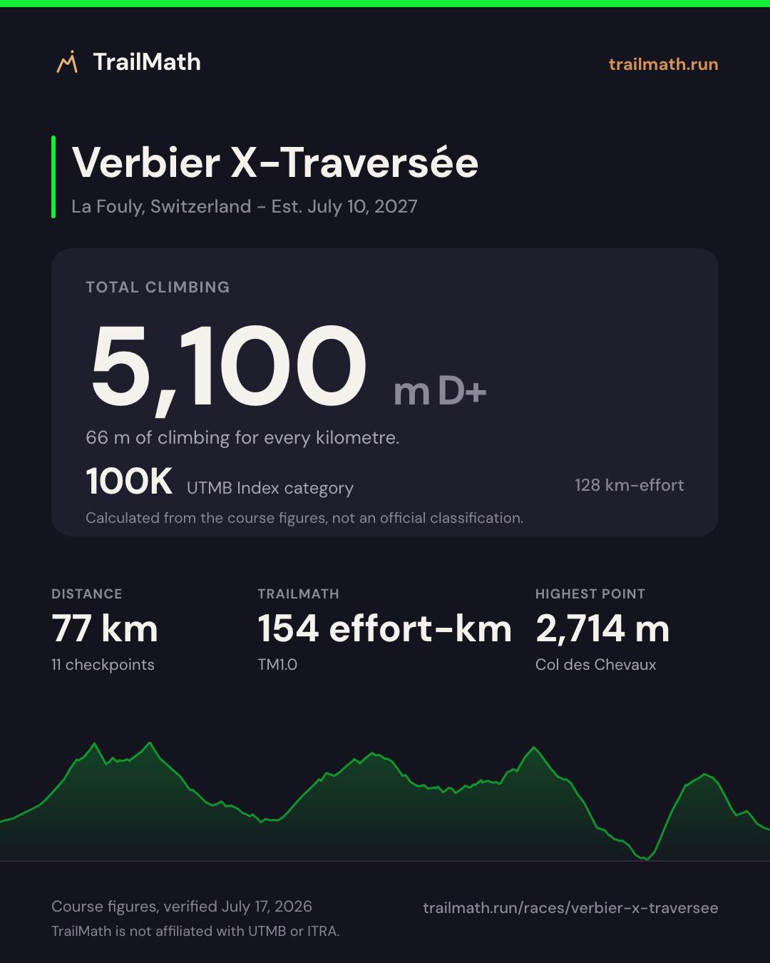
- 77 km
- 5,100 m D+
- 9 aid stations
Map, profile and checkpoints Map · checkpoints · forecast opens Jul 1 Race-day forecast is live
Race-day conditions
Weather, daylight and your arrival time at all 11 checkpoints, set to the 09:00 start.
- Start
- 09:00
- Daylight at the start
- 05:50-21:22
- Aid stations
- 9
Course profile
La Fouly, Switzerland
- Distance
- 77 km Finishes 108 m lower than it starts
- Elevation
- +5,100 m -5,208 m About 66 m of climb per km
- Highest point
- 2,714 m Col des Chevaux
Next edition Est. Sat 10 Jul 2027
Our estimate for Sat 10 Jul 2027. The organiser has not announced the date for this race yet.
- Start
- Winner ~8h42 8h42 after the start
- Sunset 12h23 after the start
- Mid-pack finish UTMB Index 500 17h28 after the start
- Sunrise 20h51 after the start
- Cutoff 26h after the start
A mid-pack runner spends about 5h05 in the dark.
Trail Verbier St-Bernard by UTMB - X-Traversée is a 77 km ultra-trail with around 5,100 m of elevation gain, starting in La Fouly, Switzerland. The overall cutoff is 26 hours. The highest point on the course is Col des Chevaux at 2,714 m. That is 66 m of climbing per kilometre. Verbier X has 4 races, from 43 to 140.3 km; this one ranks 2 of 4 by distance and 2 of 4 by climbing per kilometre.
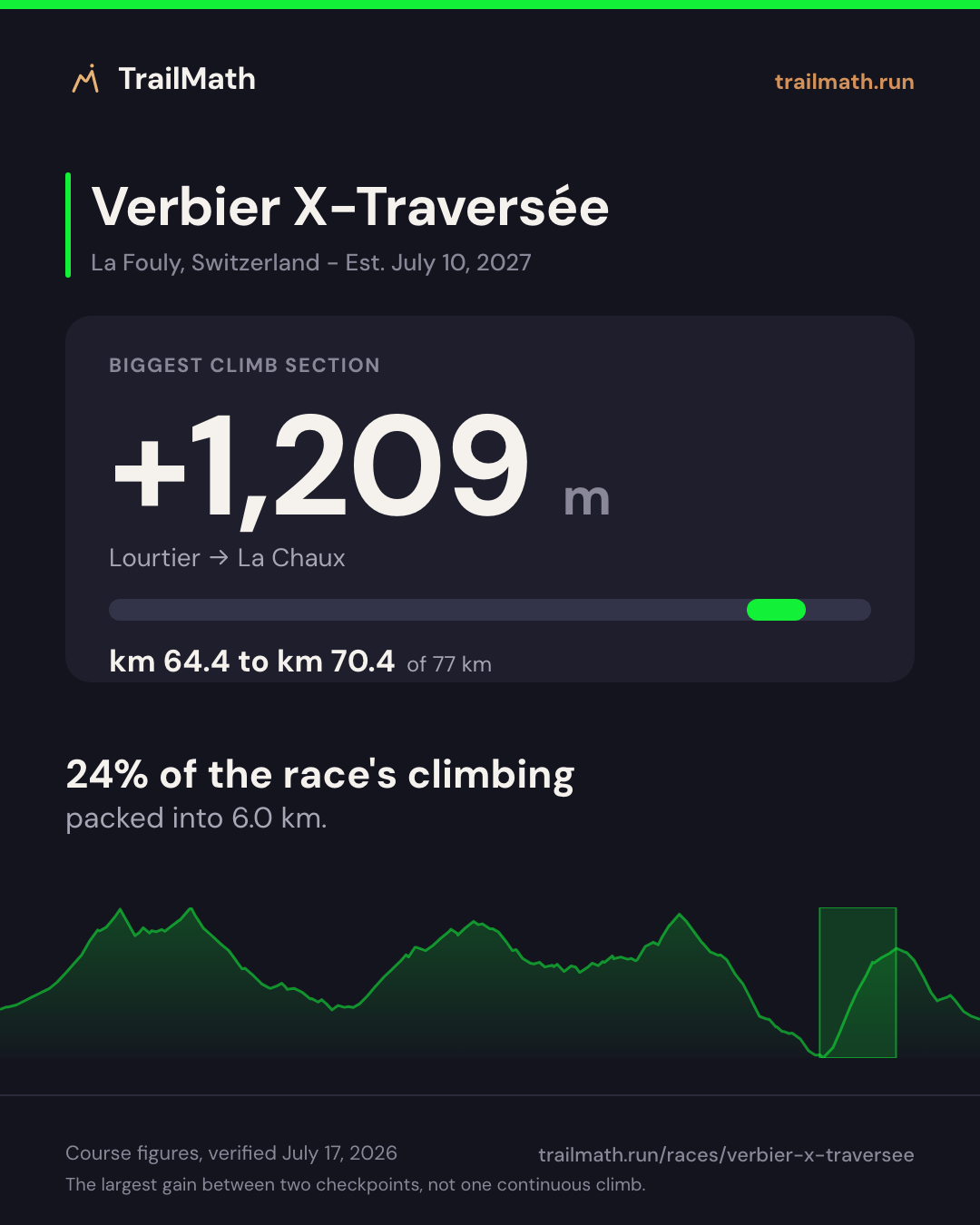
The biggest climb between checkpoints gains around 1,209 m from Lourtier (km 64.4) to La Chaux (km 70.4). The steepest sustained section on the elevation profile averages about 31% over roughly 2.1 km around km 67. Crew access is allowed at Col des Chevaux (14.9 km), Bourg-St-Pierre (26.8 km), Cabane Brunet (46.3 km), Lourtier (64.4 km) and La Chaux (70.4 km).
Data is approximate and courses change between editions - always verify against the official race guide.
Other distances at Verbier X
| Race | Distance | D+ | Cutoff | Next start |
|---|---|---|---|---|
| Verbier X-Alpine | 140.3 km | 9,127 m | 41h30 | Jul 9, 2027 |
| Verbier X-Traversée (this page) | 77 km | 5,100 m | 26h00 | Jul 10, 2027 (est.) |
| Verbier Marathon | 47 km | 2,900 m | 14h00 | Jul 9, 2027 |
| Verbier Marathon X-Treme | 43 km | 3,000 m | 13h30 | Jul 9, 2027 |
Plan against the cutoffs
Enter a goal finish time and see estimated arrivals vs checkpoint cutoffs.
Estimate your finish
One Strava connection reads your last 90 days and estimates your finish on this course. Free, no plan needed.


Course math
Four numbers worked out from this course's distance, elevation and checkpoints.
TrailMath effort-km
154 effort-km
About 17 h for a mid-pack finisher (index 500). Not a pacing guarantee.
Distance + gain ÷ 100 + loss ÷ 200, beside ITRA's gain-only km-effort. Model TM1.0.
How TrailMath works →UTMB Index category
100K
128 km-effort (distance + gain ÷ 100). Calculated from the course figures, not an official classification.
Estimate your UTMB Index →Biggest climb section
+1,209 m
Lourtier → La Chaux · km 64.4–70.4
The largest gain between two checkpoints, not one continuous climb.
Biggest descent section
−1,580 m
Cabane Panossière → Lourtier · km 53.2–64.4
The largest loss between two checkpoints. ITRA's km-effort ignores descent; TrailMath counts it: 154 km-effort.
Open in GPX Explorer →Share this race
Cards sized for Instagram and Strava.
See your training shape
Pick your weekly volume and training days to preview the plan structure - no account needed.
~39 weeks · peak ~8 h/week · 5 run + 2 strength days
For a 77 km race, aim for about 11 h/week at peak. Set your availability to 13 h/week in the app for the headroom to build there gradually.
Typical structure for your volume - your live plan adjusts sessions inside each week.
Make this your plan
Create your free account to generate the full week-by-week plan and keep it on track as your season changes.
Aid stations and checkpoints
| Checkpoint | Km | Cumulative gain (m) | Cumulative loss (m) |
|---|---|---|---|
| Start - La Fouly Services not published | 0 | 0 | 0 |
| Col Fenêtre | 9.4 | 1,103 | 9 |
| Col du Grand-Saint-Bernard | 12.7 | 1,246 | 377 |
| Col des Chevaux Crew | 14.9 | 1,506 | 394 |
| Bourg-St-Pierre Crew | 26.8 | 1,681 | 1,660 |
| Cabane de Mille | 38.6 | 2,782 | 1,905 |
| Cabane Brunet Crew | 46.3 | 3,056 | 2,556 |
| Cabane Panossière | 53.2 | 3,789 | 2,749 |
| Lourtier Crew | 64.4 | 3,813 | 4,329 |
| La Chaux Crew | 70.4 | 5,022 | 4,357 |
| Verbier (Finish) Crew Drop bag | 77 | 5,100 | 5,208 |
Data is approximate and courses change between editions - always verify against the official race guide. Source: official race guide, verified July 17, 2026 - Official race website
FAQ
How much elevation gain does Trail Verbier St-Bernard by UTMB - X-Traversée have?
Trail Verbier St-Bernard by UTMB - X-Traversée has around 5,100 m of cumulative elevation gain and 5,208 m of loss over 77 km.
What is the cutoff time for Trail Verbier St-Bernard by UTMB - X-Traversée?
The overall Trail Verbier St-Bernard by UTMB - X-Traversée cutoff is 26 hours, with intermediate time barriers at major checkpoints. Winning times are typically around 9 hours.
How long is Trail Verbier St-Bernard by UTMB - X-Traversée?
Trail Verbier St-Bernard by UTMB - X-Traversée covers approximately 77 km, starting in La Fouly, Switzerland.
What is the highest point of Trail Verbier St-Bernard by UTMB - X-Traversée?
The highest point of Trail Verbier St-Bernard by UTMB - X-Traversée is Col des Chevaux at 2,714 m.
How many aid stations does Trail Verbier St-Bernard by UTMB - X-Traversée have and which allow crew?
The checkpoint table lists 9 major aid points between the start and the finish. Crew access is allowed at Col des Chevaux (14.9 km), Bourg-St-Pierre (26.8 km), Cabane Brunet (46.3 km), Lourtier (64.4 km) and La Chaux (70.4 km).
Training for this race?
TrailMath builds periodized trail training plans around your goal race.
One Strava connection reads your last 90 days and estimates your finish on this course. Free, no plan needed.